Part I: The Imperative for a State Run on Spatial Data
This introduction sets the framework for the entire report, elevating the discussion from a mere technology upgrade to an essential requirement for achieving Vietnam’s national development goals. The report establishes the strategic context and the urgency of the issue.
1.1. The Convergence of Imperatives: Digital Transformation and Sustainable Development
The National Digital Transformation Program to 2025, with orientation to 2030, approved under Decision 749/QD-TTg of the Prime Minister, sets ambitious goals for building digital government, a digital economy, and a digital society. These goals, from providing 100% of public services online at level 4 to having the digital economy account for 30% of GDP, all imply a fundamental requirement: the ability to manage and optimize the nation’s physical resources intelligently and efficiently. However, achieving these goals in core areas such as land management, mineral resources, urban planning, and technical infrastructure will be impossible if we rely only on traditional management methods, which have revealed many shortcomings.
This report argues that achieving the strategic goals of Decision 749/QD-TTg depends directly on transforming the way the national territory is managed. A truly effective digital government is not possible while data on the nation’s most important assets, land and infrastructure, remains fragmented, unsynchronized, and unreliable. Therefore, building a unified spatial data platform is not just an information technology project; it is a key factor and a prerequisite for the National Digital Transformation Program to succeed comprehensively and sustainably.
1.2. From “Heart” to “Central Nervous System”: A New Metaphor for National Governance
The UNIGIS white paper used a powerful metaphor when it called the geographic information system (GIS) a “digital heart,” able to pump a smooth, unified flow of data. This image is intuitive and emphasizes the central role of GIS in circulating the “bloodstream” of data. However, to better reflect the potential and strategic role of this technology in the context of modern national governance, this report proposes a more comprehensive metaphor: the National Spatial Data Infrastructure (SDI) is the central nervous system of the Government.
This metaphor not only covers the “pumping” and “circulating” functions of the heart, but also emphasizes the other important functions of a nervous system:
- Sensory Input: Continuously monitoring the state of the territory, resources, and infrastructure through diverse data sources (remote sensing, IoT, field reports), like the senses gathering information from the environment.
- Processing: Aggregating, analyzing, and converting raw data into knowledge and predictive information, similar to the brain processing signals.
- Coordinated Response: Enabling agencies, departments, and sectors to make synchronized decisions and take coordinated action based on a common information picture, like the nervous system controlling the parts of the body in harmony.
Reframing the role of GIS from a “heart” to a “central nervous system” helps us recognize more clearly that this is not just a system for storing and providing data, but an intelligent, dynamic, and adaptable governance platform, a core element for building a proactive, enabling, and effective government.
1.3. The Global Context: Lessons from Successes and Failures in Building International SDIs
Vietnam is not alone on the journey to build a national spatial data infrastructure. Many countries have gone before and offer valuable lessons. Studying international cases is not only about learning technology but, more importantly, about understanding the policy and institutional structures and the pitfalls to avoid.
- Successes:
- Singapore (GeoWorks): Singapore has turned spatial data into an economic asset. The GeoWorks platform serves not only state management but also acts as an incubator for startups in geospatial technology (GeoTech), creating a vibrant ecosystem. The lesson is a vision that goes beyond the government itself, treating SDI as a driver of economic growth.
- South Korea (K-GeoPlatform): South Korea focuses on providing high-quality open data to the public and businesses, promoting transparency and innovation. The lesson is a strong commitment to transparency and community participation.
- European Union (INSPIRE Directive): INSPIRE is a legal framework that requires member states to comply with common standards for spatial data to ensure cross-border interoperability. The lesson is the power of a clear, binding legal framework to break down barriers to data sharing.
- Common pitfalls to avoid:
- Lack of political will: Many SDI projects fail because they do not receive sustained support from the highest levels of leadership, leaving them as the effort of the technology or natural resources and environment sector alone.
- Unsustainable funding: Projects are often funded in short-term phases, with no budget to ensure long-term maintenance, updating, and operation, which are vital to the system.
- Failure to enforce standards: Issuing standards is necessary, but without an authority with enough power to supervise and compel compliance, standards exist only on paper.
These lessons show that Vietnam’s biggest challenge lies not in technology, but in building an institutional, legal, and financial framework strong enough to lead and sustain this effort in the long term.
Part II: Analyzing the Foundational Cracks: Systemic Inefficiencies in Vietnam’s Public Administration
This part provides an in-depth, critical analysis of the four core challenges identified in the white paper. The report goes beyond simple description to quantify their impact and expose the deep systemic problems.
2.1. The True Cost of “Data Islands”: Quantifying Duplication and Contradictory Decisions
The white paper correctly identified data fragmentation among departments, agencies, and sectors as a core challenge, leading to “overlapping data and inconsistent figures.” The Department of Natural Resources and Environment manages cadastral records, the Department of Construction manages construction planning, the Department of Transport manages the transport network, and each infrastructure unit has its own data. However, to understand how serious the problem is, we need to analyze its root causes and real consequences.
These “data islands” are not the product of random weakness, but the inevitable result of an administrative structure divided along vertical sectors, in which each agency has its own legal basis, procedures, and culture of “data ownership.” The process unfolds as follows: First, the fragmented administrative structure creates separate “data fiefdoms.” Next, the absence of a mandatory data-sharing mechanism and standards leaves these fiefdoms isolated. The direct consequence is inconsistent figures. But a secondary and far more harmful consequence is slow, contradictory, and poorly grounded decision-making on cross-sector issues.
Consider the following real-world scenarios:
- A foreign investor wants to build a high-tech factory. They need data on land use planning (from the Department of Natural Resources and Environment), detailed construction planning (from the Department of Construction), transport connectivity (from the Department of Transport), and electricity and water supply capacity (from the infrastructure units). Collecting and cross-checking information from these scattered sources can take months and, worse, the information may contradict itself. This delay and risk can lead the investor to move to another country with a more transparent information environment.
- A city metro line project is planned on an outdated land use planning map. During implementation, the project runs into a series of legally built structures that have since sprung up, causing compensation and site clearance costs to soar, wasting state budget and delaying the schedule by years.
The deepest impact of “data islands” is that it directly contradicts the core principle of an “enabling government.” An enabling government demands initiative, flexibility, and the ability to create a favorable environment for citizens and businesses. However, data fragmentation forces the state apparatus to operate passively, handling each issue in isolation, creating countless barriers and transaction costs for society. It erodes national competitiveness and weakens public trust in governance capacity.
2.2. The Planning Paradox: When Uncoordinated Master Plans Hinder Sustainable Development
The white paper cited a typical example of a planning conflict: an area designated as a park in the construction plan but located within an industrial zone in the land use plan. This is not an isolated error but a systemic paradox, stemming from a lack of coherence in the legal and institutional framework.
The root of the problem is that Vietnam has multiple laws governing different types of plans (the Land Law, the Construction Law, the Planning Law, and other sector-specific laws). Each law empowers a ministry or a department to build the plan that has the “highest legal status” in its own field. These plans are usually prepared in parallel, on different base maps, with different sets of standards, and, most importantly, with no legal mechanism strong enough to force them to be cross-checked and reconciled on a single spatial reference system.
When there is no technology platform and no higher legal principle to force these plans to fit together, conflict is not an accident but a result programmed into the system. The consequences of this paradox are extremely harmful. It creates enormous uncertainty for investors and society. A business licensed to invest in a plot of land under the land use plan may see its project stalled because the plot is caught up in another plan. This causes not only direct economic damage but also destroys trust in the investment environment. At the macro level, it makes sustainable development goals unattainable. The Government cannot pursue a long-term, coherent vision for the country when its most important strategic guidance tools contradict and cancel each other out. This is a self-inflicted wound the system has dealt to the national economy.
2.3. The Trap of Passive Reaction: The Inability to Proactively Manage National Assets and Risks
The UNIGIS report points out that traditional management is often “reactive,” able to act only after an incident has occurred, especially in monitoring changes such as illegal construction, illegal mineral extraction, or deforestation. This “passive reaction trap” is not only an inefficiency but also a significant loss of state control and a failure in the role of protecting national assets.
This passivity stems from dependence on manual, periodic monitoring methods and reports from citizens, which are slow, incomplete, and easily overlooked. Consider some specific examples:
- Thousands of small-scale illegal extensions and encroachments on canals and waterways occur across a large city. Each individual violation may be small, but their cumulative impact clogs the drainage system and is one of the main causes of increasingly severe flooding. Management agencies can detect and handle only a small fraction of them, often after the consequences have already occurred.
- Illegal deforestation to plant industrial crops is often detected only when periodic satellite images are analyzed or when forest rangers go on patrol, by which time dozens of hectares of forest have been wiped out. The chance of recovery is almost zero.
The secondary consequence of this situation is that when a problem is identified (for example, a river polluted by illegal discharge), the damage is usually already severe and the cost of remediation is extremely high, if not impossible. But the deepest impact is a crisis of governance. The lack of real-time spatial information means the government is often the last to know about important changes taking place on its own territory, ceding the initiative to those who violate the law. It weakens the authority of the state and its role as steward of national resources. This weakness can encourage other illegal behavior, creating a vicious cycle of environmental degradation and disregard for the law.
2.4. The Hidden Burden: Inefficiency in Operating the Nation’s Essential Infrastructure
The white paper describes the inefficiency of managing millions of kilometers of electricity, water supply and drainage, and telecommunications network infrastructure using paper records or static CAD files. Although less visible, this burden is a kind of “hidden tax” on the entire economy.
The lack of an accurate, integrated digital map system of technical infrastructure leads to direct consequences:
- After a storm, power repair crews spend hours, even days, pinpointing the location of a broken power pole or a severed cable amid the chaos, causing prolonged power outages that affect business operations and people’s daily lives.
- During construction of a building project, the contractor accidentally digs into a water supply pipe or underground fiber-optic cable because the map is inaccurate, causing damage worth billions of VND, disrupting services, and endangering workers.
The secondary consequences are direct economic losses: businesses have to close because of power outages, thousands of cubic meters of clean water are lost from undetected leaking pipes, and construction projects are stalled. Operating costs for utility providers rise, and these costs are ultimately passed on to consumers. But the deepest impact is that it creates a fragile and less sustainable urban environment. With threats related to climate change on the rise (storms, floods, landslides), the inability to manage and quickly repair essential infrastructure poses a direct threat to national security and public welfare. It complicates every future urban development effort, because no one knows for certain what lies underground.
Part III: The National Spatial Data Infrastructure (SDI): Building Vietnam’s Digital Central Nervous System
This part converts the technical concept of GIS into a strategic governance framework. It details the components needed beyond software, with an emphasis on policy, standards, and human capital.
3.1. Beyond Maps: Defining the Four Pillars of a National SDI
The white paper defines GIS as a comprehensive system comprising “technology, processes, standards, and people.” This is an accurate definition, but to build a national strategy it needs to be expanded and structured into the four internationally recognized pillars of a Spatial Data Infrastructure (SDI):
- Technology: This is the most tangible part, including hardware (servers, networks), software (GIS, databases), and platforms (web, mobile). These are the tools for storing, processing, and distributing data.
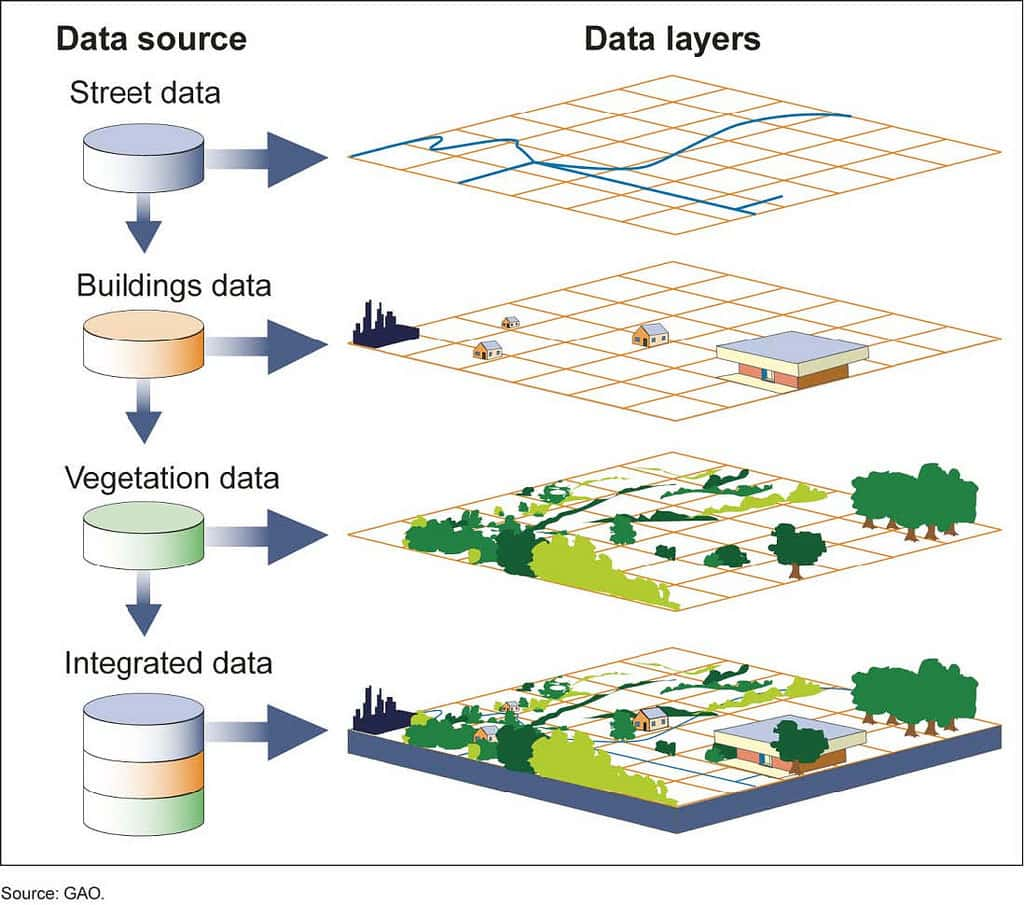
- Data: This is the “blood” of the system. It includes foundation spatial datasets (base maps, administrative boundaries, terrain), thematic datasets (current land use, planning, technical infrastructure), and most importantly standards (metadata, quality, norms) to ensure data can be shared and used consistently.
- People: This includes technical experts who build and maintain the system, professional staff who use the system in their daily work, and leaders who make decisions based on information the system provides. Human capacity is the deciding factor in whether the system’s potential is fully realized.
- Governance: This is the most important pillar and also the greatest challenge. It includes the legal framework (laws, decrees) and institutions (coordination councils, inter-agency agreements) to mandate data sharing, define the roles and responsibilities of the parties, and resolve disputes.
Of these four pillars, technology is the easiest to buy. Governance, by contrast, is the hardest to build but the most decisive. Without a strong governance framework, every investment in technology will only create more sophisticated systems that remain isolated, unable to break down the “data islands,” and fail to create overall value for the nation.
3.2. The “Single Source of Truth”: Technical and Political Challenges in Building the National Spatial Database
The white paper advocates building a centralized, standardized shared spatial database (Geodatabase) that becomes the “single source of truth” for the entire system. This is an ideal and extremely necessary goal, but realizing it is an enormous challenge, involving both technical and political aspects.
- Technical challenges:
- Data harmonization: How can data from different sources, with different models, structures, and formats (for example, data from CAD files, Shapefiles, spreadsheets), be merged into a single database?
- Quality assurance: Legacy data from paper records or poorly digitized files often contains many errors. Cleaning, checking, and ensuring the accuracy of terabytes of data is costly and time-consuming work.
- Update process: How can a synchronized and sustainable data update process be established, ensuring that when an agency changes information, the change is reflected immediately and consistently across the whole system?
- Political challenges: This is the core and hardest part of the problem.
- Determining data authority: When the cadastral data of the Ministry of Natural Resources and Environment conflicts with the planning data of the Ministry of Construction for the same land parcel, whose data will be considered the “truth”?
- Redefining “data ownership”: How can the mindset be changed from “the data belongs to our ministry/department” to “data is a national asset”? This requires decisive political direction from the highest level to overcome institutional inertia and resistance from agencies used to controlling their information “fiefdoms.”
Building a National Spatial Database is less a technical project than a complex political negotiation. Its success depends on establishing a neutral and sufficiently powerful arbitration body (for example, a National SDI Council) with the authority to enforce standards, adjudicate inter-ministerial disputes, and ensure that the common interest of the nation is placed above the interests of individual sectors.
3.3. From Data to Intelligence: A Practical Guide to Applying Spatial Analysis
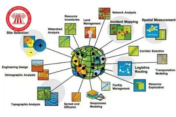
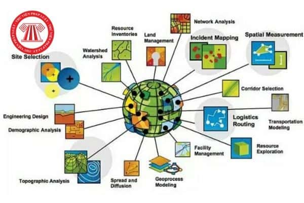
The greatest value of GIS lies not in producing beautiful maps, but in the ability to perform spatial analysis that converts raw data into knowledge for decision-making. The white paper listed the main analytical functions: Overlay Analysis, Network Analysis, Buffer Analysis, and Modeling & Prediction. For policymakers to see the value of these tools clearly, those abstract concepts need to be turned into concrete applications for Vietnam’s challenges.
The table below illustrates how spatial analysis functions can be applied to solve specific policy problems, delivering clear value for governance.
Table 1: Applying Spatial Analysis to Policy Challenges in Vietnam
| GIS Analysis Function | Policy Application in Vietnam | Example Scenario | Value in Decision-Making / Outcome |
|---|---|---|---|
| Overlay Analysis | Land Use & Construction Planning Management | Overlay the national land use plan, a province’s construction plan, and the boundary of a proposed industrial park project. | Automatically identifies non-compliant areas, preventing legal disputes and wasted resources. Reduces project appraisal time by 30%. |
| Network Analysis | Fire Fighting, Emergency Medical Services & Urban Logistics | Calculate the fastest route for fire engines from multiple stations to a fire in the old quarter, taking real-time traffic conditions into account. | Reduces emergency response time, saving lives and property. Optimizes waste collection routes, saving fuel and time. |
| Buffer Analysis | Environmental Management & Public Health | Create a 2 km buffer around a chemical plant to identify all schools and residential areas at risk of being affected in the event of a leak. | Enables proactive emergency response planning, targeted notifications to residents, and evidence-based planning regulations. |
| Modeling & Prediction | Disaster Management & Urban Growth | Use elevation, rainfall, and vegetation cover data to model and predict areas at high risk of landslides in mountainous provinces. Simulate urban sprawl based on population growth trends. | Enables the development of early warning systems, targeted resettlement programs, and proactive infrastructure planning to meet future needs. |
Part IV: The Critical Implementation Roadmap: Analyzing the Three-Phase Plan
This part critically evaluates the roadmap proposed by UNIGIS. The report supplements the plan with risk assessments, key success factors, and the important governance actions needed at each phase.
4.1. Phase 1: Digitization and Standardization – A Solid Foundation
Phase 1, as proposed, focuses on creating a foundational spatial database (Geodatabase), digitizing paper/CAD documents, and complying with national standards such as VN-2000. The white paper presents this as a purely technical task, but in reality it is the most resource-intensive phase and the most politically contentious.
- Critical analysis: This is the “digging the foundation” phase. If this foundation is not solid, the entire structure will collapse. Treating it merely as digitization work is a strategic mistake. It must be seen as a process of establishing national data authority and standards.
- Risks:
- Budget overruns: The cost of large-scale digitization, cleaning, and quality verification of data is often underestimated, causing the project to stall midway.
- Poor data quality: “Digitizing garbage,” that is, moving erroneous data from paper to computer, will create an unreliable and useless system.
- Inter-agency disputes: Agencies will argue over which standards to use, which data structures to use, and who is responsible for the accuracy of the data.
- Stuck in the pilot stage: The project risks never getting past the pilot stage in a few localities due to the lack of a clear nationwide scale-up plan.
- Key Success Factors:
- Centralized, authoritative direction: There must be a national steering committee strong enough to make final decisions on standards and resolve conflicts.
- A clear legal framework: A decree or law is needed requiring ministries and sectors to share data according to the issued standards.
- A phased, prioritized approach: Start with the few most important and highest-impact datasets (for example, administrative boundaries, the main transport network, the national land use plan) rather than trying to digitize everything at once.
4.2. Phase 2: Integration and Analysis – The Integration Engine
Phase 2 focuses on developing application programming interfaces (APIs) to connect systems, building sector-specific WebGIS/Mobile GIS applications, and building staff capacity. In this phase, the challenge shifts from creating data to system integration and user adoption.
- Critical analysis: If Phase 1 is building the “data warehouse,” then Phase 2 is building the “pipelines” and “factories” that turn data into services. Failure in this phase is usually due not to technology but to human and organizational factors.
- Risks:
- Technical incompatibility: The legacy systems of ministries and sectors may not integrate easily with the new GIS platform, requiring significant cost and effort to build custom connectors.
- Resistance to change: Staff used to the old paper-based workflows or simple software may feel threatened or unwilling to learn a complex new system.
- Unfriendly applications: The applications developed may be too complex and ill-suited to real operational needs, leading users not to use them.
- Key Success Factors:
- Adopting open standards: Mandate the use of open standards (for example, from the Open Geospatial Consortium, OGC) to avoid dependence on a single vendor (vendor lock-in) and ensure future interoperability.
- User-centered design: End users (operational staff) must be involved from the very beginning of application design to ensure it solves their actual problems.
- Large and sustained investment in training: A large-scale training and change management program is needed that teaches not only how to “click” but also changes the mindset about how to use data in daily work.
4.3. Phase 3: Smart and Open Operations – The Intelligence Layer
Phase 3 is the final vision: building Intelligent Operations Centers (IOC), applying AI/machine learning for forecasting, and creating public portals to increase transparency. This phase depends entirely on the success of the previous two phases.
- Critical analysis: This is the phase of transformation from a management tool into a governance platform. It demands a deep cultural change across the entire government.
- Risks:
- “Dashboard theater”: IOCs can become impressive showrooms with big screens flashing data, but without actually leading to better decisions or faster action. Data is displayed but not used.
- Erosion of public trust: Public portals that provide inaccurate or outdated data will backfire, weakening the trust of citizens and businesses in the government.
- Privacy concerns: Aggregating large amounts of data on land, property, and people can raise concerns about surveillance and the security of personal information.
- Key Success Factors:
- A clear governance model for the IOC: It must be clearly defined who has the authority to make decisions based on information from the IOC, and the IOC must be integrated into formal direction and operating processes.
- Strong data security and privacy policies: Strict legal regulations are needed on the collection, use, and protection of personal data.
- Commitment to open data principles: Encourage participation by the public and the private sector by providing data in open, easily accessible formats, promoting innovation and social oversight.
Part V: Strategic Imperatives and Action Recommendations for National and Provincial Leaders
This is the culminating part, converting all the analysis into a clear action plan for policymakers. The report is structured as a series of high-level strategic imperatives, each supported by specific, measurable recommendations.
5.1. Imperative 1: Establish a Unified Legal and Governance Framework
- Recommendation 5.1.1: Establish a National Council on Spatial Data Infrastructure (NCSDI), chaired by a Deputy Prime Minister, with ministerial-level leaders as members. This body will have the highest authority to set policy, adjudicate inter-agency disputes, and oversee the national SDI program.
- Recommendation 5.1.2: Draft and promulgate a National Geospatial Data Law. This law will mandate the sharing of geospatial data among government agencies, establish the principle that geospatial data is a national asset, and define legal responsibility for data quality and security.
5.2. Imperative 2: Ensure Sustainable, Long-Term Funding
- Recommendation 5.2.1: Move beyond the project-based funding model. Set aside a fixed percentage of the annual national information technology budget for developing and, especially, maintaining and continuously operating the national SDI.
- Recommendation 5.2.2: Actively explore Public-Private Partnership (PPP) models for developing applications and services based on non-sensitive data. Pursue funding and technical assistance from international development partners such as the World Bank (WB) and the Asian Development Bank (ADB), by positioning SDI as essential infrastructure for climate resilience and economic growth.
5.3. Imperative 3: Launch a National Program for Geospatial Capacity Building
- Recommendation 5.3.1: Partner with leading domestic universities (for example, Hanoi University of Science and Technology and Ho Chi Minh City University of Technology) to overhaul curricula in geography, information technology, and land management to create a high-quality GIS workforce.
- Recommendation 5.3.2: Establish a mandatory training program on “Geospatial Literacy” for all mid-level and senior managers in relevant ministries and sectors to ensure they can effectively use the new systems in decision-making.
5.4. Imperative 4: Prioritize Open Standards and Phased, Modular Deployment
- Recommendation 5.4.1: Mandate the use of Open Geospatial Consortium (OGC) standards for all government GIS procurement and development activities. This prevents long-term dependence on a single vendor and ensures future interoperability and scalability.
- Recommendation 5.4.2: Reject the “big bang” approach. Launch the national program with a few high-impact, highly visible projects in a few key provinces and cities to demonstrate value, build momentum, and learn from early challenges before nationwide rollout.
Table 2: Implementation Framework for the National Spatial Data Infrastructure (SDI)
| Phase | Main Objectives | Lead Agency & Stakeholders | Key Success Factors | Potential Risks & Mitigation Strategies | Key Performance Indicators (KPIs) |
|---|---|---|---|---|---|
| 1: Foundation (Years 1-3) | Create the national spatial database and standardize the core datasets. | Lead: Ministry of Natural Resources and Environment (MONRE). Stakeholders: All ministries, provincial governments. | Strong political direction from the NCSDI. Adequate long-term funding. | Risk: Inter-agency resistance. Mitigation: NCSDI arbitration. Risk: Poor-quality legacy data. Mitigation: Apply rigorous QA/QC processes. | National Geospatial Data Law passed. Core data standards approved. 80% of priority datasets digitized and standardized. |
| 2: Integration (Years 3-5) | Develop cross-sector APIs. Deploy core operational applications (land management, licensing). | Lead: Ministry of Information and Communications (MIC). Stakeholders: MONRE, Ministry of Construction, Ministry of Transport, user departments and sectors. | Adoption of open standards. User-centered application design. Comprehensive training program. | Risk: Vendor dependence. Mitigation: Mandate OGC standards. Risk: User non-acceptance. Mitigation: Continuous training and user feedback. | 75% of target agencies connected via API. 10 key Web/Mobile GIS applications deployed and actively used. 5,000 staff trained. |
| 3: Intelligence (Year 5+) | Establish national/provincial IOCs. Integrate AI/ML for predictive analytics. Launch public data portals. | Lead: Government Office, provincial People’s Committees. Stakeholders: All agencies, the public, the private sector. | Clear data governance for the IOC. Strong data privacy law. Commitment to open data. | Risk: Data on display only, not for action. Mitigation: Integrate the IOC into formal decision-making processes. Risk: Public loss of trust. Mitigation: Radical transparency about data use and security policies. | National IOC fully operational. Public planning and land information portal reaches 1 million+ users/year. Measurable improvement in at least 3 indicators (for example, emergency response time). |
Part VI: Charting the Course: Vietnam’s Geospatial Future
This concluding part synthesizes the report’s main arguments and paints a compelling picture of a future Vietnam run on spatial intelligence. It goes beyond the technical to describe the economic and social benefits.
6.1. Vision to 2035: A Nation Running on a Spatial Foundation
Picture Vietnam in 2035, where the National Spatial Data Infrastructure has become a reality and is deeply embedded in every aspect of life and governance:
- A small business owner, with just a smartphone, can access the public portal to instantly check the planning information, legal status, and infrastructure connectivity of a plot of land they intend to invest in, minimizing risk and saving time.
- An emergency situation manager at the operations center of a Central Vietnam province can coordinate rescue, medical, and police forces in sync on a common real-time operational picture to respond to a storm, optimizing the evacuation of residents and the allocation of resources.
- A national-level policymaker in Hanoi can run simulation models of the long-term environmental and social impacts of different economic development scenarios (for example, building a coastal economic zone versus developing high-tech agriculture) to make sustainable choices for the country’s future.
This is not a science fiction scenario. It is the inevitable result of successfully implementing a national SDI, turning data from a storage burden into a strategic asset.
6.2. Conclusion: An Investment in the Infrastructure of All Infrastructure
The journey to build digital government is a long process that requires a strategic vision and a solid technology foundation. Investing in a comprehensive Geographic Information System (GIS), or more precisely a National Spatial Data Infrastructure (SDI), is not an information technology expense. It is an investment in the nation’s foundational infrastructure, as important as roads, ports, and the power grid in the 21st century.
It is the “infrastructure of infrastructure,” because it creates a smooth, transparent, and intelligent flow of data that underpins every management and operational decision related to other physical infrastructure. It is the essential step to fully realize the goals of the National Digital Transformation Program, toward a more efficient, transparent, resilient, and prosperous Vietnam. UNIGIS has put forward a valuable proposal, and the task of leaders is to turn that technological vision into a successful national governance strategy.