Overview
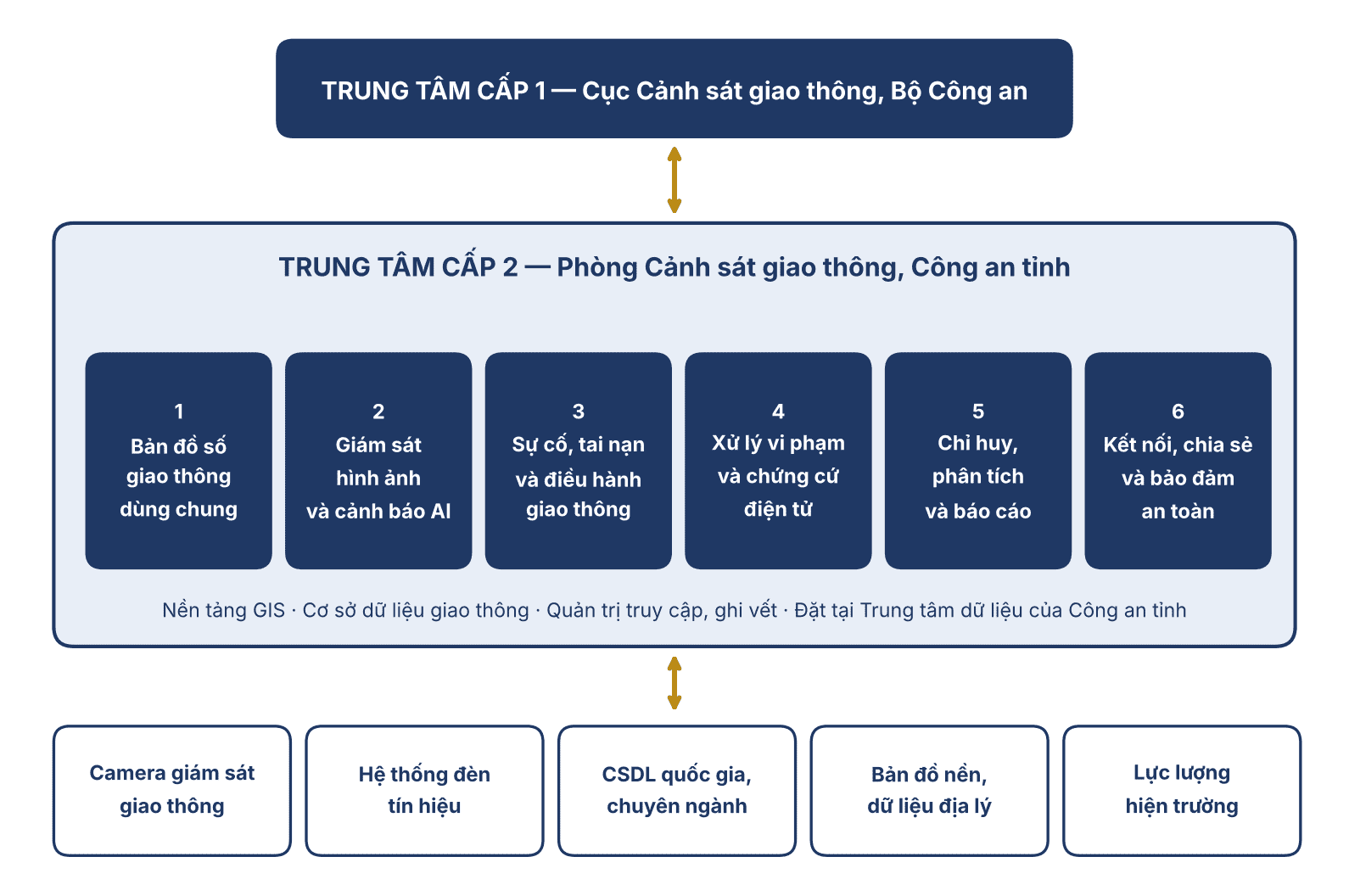
The Provincial Traffic Monitoring and Operations System is a technology solution built on a digital map (GIS) platform. It serves the provincial traffic data, management, monitoring, violation handling, and operations center (Level 2 Center), located at the Traffic Police Department (Phòng Cảnh sát giao thông) of the Provincial Police (Công an tỉnh).
The system integrates and displays, on one unified digital map, data sources including camera images, traffic signals, incidents, accidents, forces on duty, and artificial intelligence alerts. It supports leaders and commanders in monitoring the situation, making decisions, directing forces, handling violations, and reporting results in ensuring traffic order and safety in the province.
The solution is designed in line with the orientation of the Project “Building the Traffic Data, Management, Monitoring, Violation Handling and Operations Center for 2026 - 2030, with a vision to 2050”, and ensures connectivity and interoperability with the Level 1 Center located at the Traffic Police Department (Cục Cảnh sát giao thông), Ministry of Public Security (Bộ Công an).
Basis and deployment requirements
On September 29, 2026, the Government issued Resolution No. 298/NQ-CP on the Plan to implement Resolution No. 05-NQ/ĐU dated June 12, 2026 of the Government Party Committee, implementing the Project under Decision No. 456/QD-TTg dated March 20, 2026 of the Prime Minister. Accordingly, the national traffic data center is organized under a unified model from the central to the local level, consisting of a Level 1 Center at the Traffic Police Department and 34 Level 2 Centers at the Traffic Police Departments of provincial and city Police.
The basic requirements for building and deploying at the provincial level include:
- uniform compliance with the overall architecture, data architecture, shared data dictionary, technical standards and regulations, and data connection and sharing principles issued by the competent authority;
- priority on making use of existing infrastructure, data, equipment, and resources;
- ensuring cybersecurity, data security, and information system security; granting data access rights appropriate to purpose and authority;
- ensuring the legal validity and traceability of the electronic evidence chain;
- taking practical effectiveness as the measure: improving traffic operations capacity, strengthening the prevention, detection, and handling of violations, and reducing traffic accidents and congestion.
System components
The system consists of six functional modules that share one database and one digital map platform, serving user groups at the Level 2 Center and related units:
- Module 1: Shared traffic digital map (duty officers, duty commanders; analysts): integrates the basemap, administrative unit boundaries, road network, terrain, and thematic data layers on one unified map.
- Module 2: Video monitoring and artificial intelligence alerts (monitoring duty staff; Traffic Police Department leaders): connects and centrally displays images from the traffic monitoring camera system, as well as local cameras, cameras of organizations and individuals, and other sources, in accordance with regulations and authorization levels.
- Module 3: Incident, accident management and traffic operations (commanders; Traffic Police forces): receives, verifies, locates, and classifies traffic incidents and accidents from multiple sources of information; each case is managed in one unified file, from receipt through to closure.
- Module 4: Violation handling and electronic evidence chain management (violation handling officers; Department leaders): receives violation detection data from the monitoring system; compiles statistics and analysis by route, area, type of behavior, and time.
- Module 5: Command, analysis, and reporting (Provincial Police leaders; Department leaders): a command dashboard summarizing the traffic order and safety situation in the province, displayed on the large screen at the Center.
- Module 6: Data connection, sharing, and information security (system administrators): connects and shares data with the Level 1 Center (Traffic Police Department), national databases, and sector-specific databases under the overall architecture and shared data dictionary issued by the Ministry of Public Security.
Main functions
1. Shared traffic digital map
- Integrates the basemap, administrative unit boundaries, road network, terrain, and thematic data layers on one unified map.
- Manages the locations of traffic signs, speed limits by route segment, and traffic service points (gas stations, medical facilities, rest stops, etc.).
- Visually displays cameras, traffic signals, accident black spots, and frequently congested areas in real time or over a selected period.
2. Video monitoring and artificial intelligence alerts
- Connects and centrally displays images from the traffic monitoring camera system, as well as local cameras, cameras of organizations and individuals, and other sources, in accordance with regulations and authorization levels.
- Receives alerts from artificial intelligence models (congestion, abnormally stopped or parked vehicles, traffic violations, incidents on routes) and locates them directly on the map.
- Artificial intelligence models are verified and evaluated before being put into operation, as required by the Project.
3. Incident, accident management and traffic operations
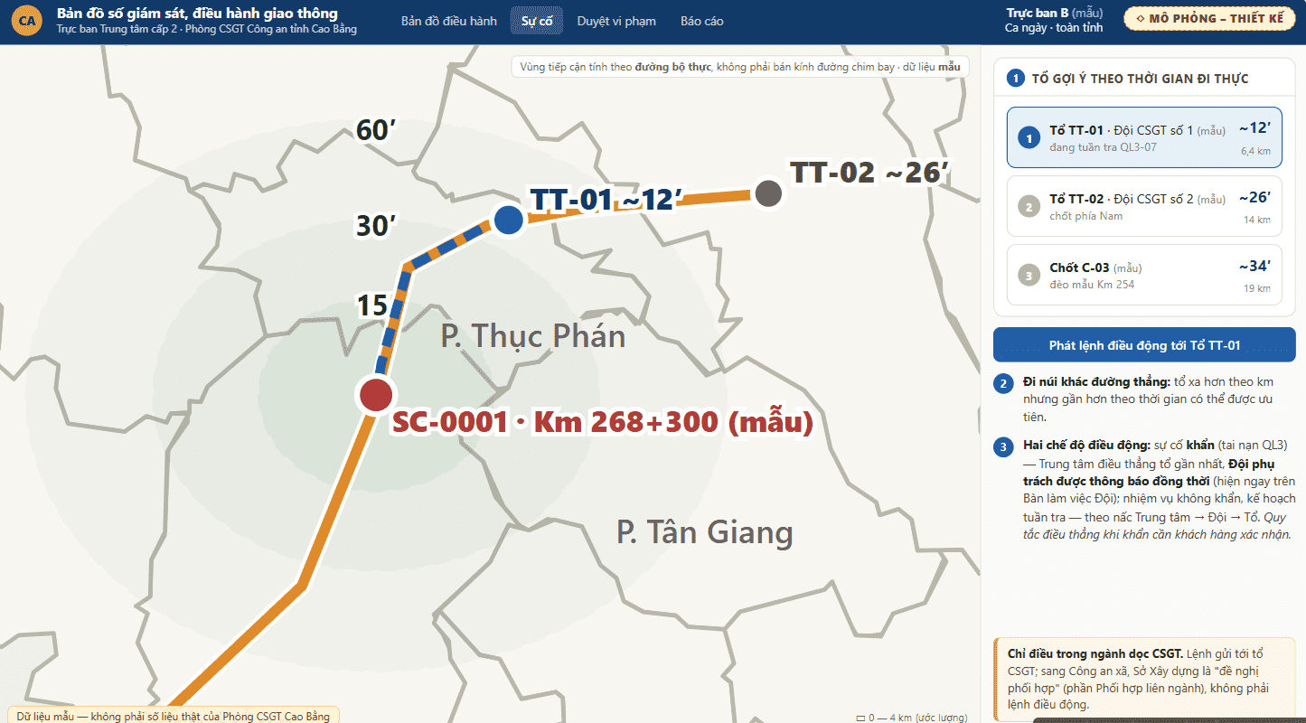
- Receives, verifies, locates, and classifies traffic incidents and accidents from multiple sources of information; each case is managed in one unified file, from receipt through to closure.
- Proposes the nearest forces and vehicles; assigns tasks and tracks handling progress; directs traffic diversion and guidance according to plans.
- Connects the traffic signal system according to the roadmap to support traffic control and regulation.
- Fully records orders, timestamps, and responsible personnel, to support inspection, evaluation, and lessons learned.
4. Violation handling and electronic evidence chain management
- Receives violation detection data from the monitoring system; compiles statistics and analysis by route, area, type of behavior, and time.
- Supports tracking the electronic handling of administrative violations, carried out according to the professional procedures prescribed by the Ministry of Public Security.
- Manages images and data that serve as electronic evidence, ensuring integrity and traceability throughout the data lifecycle.
5. Command, analysis, and reporting
- A command dashboard summarizing the traffic order and safety situation in the province, displayed on the large screen at the Center.
- Heat maps of accidents, violations, and congestion; trend analysis to support planning for traffic order and safety, including peak periods and major events.
- Automatically compiles figures and regular and ad hoc reports from the data being processed, reducing intermediate reporting.
6. Data connection, sharing, and information security
- Connects and shares data with the Level 1 Center (Traffic Police Department), national databases, and sector-specific databases under the overall architecture and shared data dictionary issued by the Ministry of Public Security.
- Grants access rights by unit, area, and data type; logs all data access and usage actions.
- Designed to ensure cybersecurity, data security, and information system security by classification level; operates in the network environment of the Police forces.
Key characteristics
- Unified on one map. Cameras, traffic signals, incidents, accidents, forces, alerts, and traffic data layers are displayed simultaneously on one shared digital map.
- Consistent with the Project’s overall architecture. Ensures connectivity and interoperability with the Level 1 Center; complies with the architecture, data dictionary, and connection standards; does not create an independent, closed system.
- One file across the whole process. Each incident, accident, or case is managed under a single code from receipt and dispatch through to the results report, with no need to re-enter data between units.
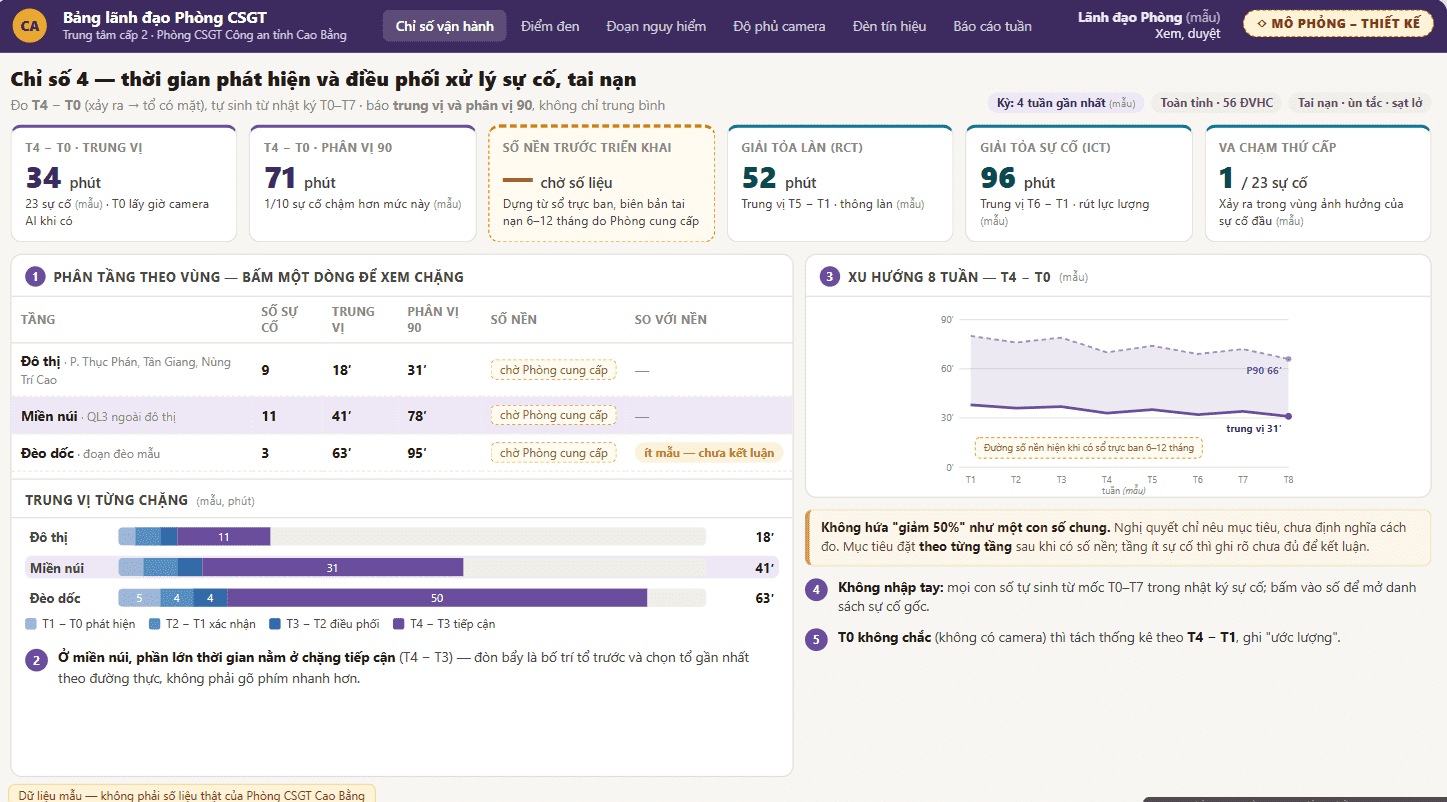
- Measurable operational effectiveness. The timestamps of detection, receipt, coordination, and handling are recorded automatically, providing a basis for evaluating the handling time of traffic incidents and accidents.
- Builds on existing infrastructure. Priority is given to connecting and making use of existing cameras, transmission infrastructure, information technology equipment, and data; this saves cost and avoids wasted investment.
- Secure, controlled, traceable. Access rights are granted according to authority and every access is logged; the electronic evidence chain is kept intact, serving state management work.
Deployment model
The system is deployed at the Level 2 Center, located at the Traffic Police Department of the Provincial Police, according to the following principles:
- Installed at the Level 2 Center. Operates within the infrastructure of the Police forces and connects to the Level 1 Center over transmission infrastructure according to the Project’s common design; the network is segmented and external connection points are tightly controlled.
- Reuse and connect existing infrastructure. Connects existing surveillance cameras, traffic signal systems, operational databases, and geographic data; able to take in new data sources according to the Project’s roadmap.
- Phased deployment. Deployed in phases, starting with core functions, with acceptance at each milestone; scale is expanded only after results are evaluated, in line with the principle of controlling investment effectiveness across the project lifecycle.
Benefits
Applying the system contributes to the Project’s target indicators for 2030, including:
| Project indicators to 2030 | Target |
|---|---|
| Level 2 Centers connected to the Level 1 Center | 100% |
| Traffic order and safety data and key traffic data connected and shared | 100% |
| Administrative violations of traffic order and safety handled electronically | ≥ 90% |
| Time to detect and coordinate the handling of traffic incidents and accidents | Reduced by ≥ 50% |
| System availability | ≥ 99.5% |
| Artificial intelligence models verified and evaluated before operation | 100% |
Note: The indicators above are general targets of the Project under Resolution No. 298/NQ-CP, not commitments specific to this solution.
Intended users
- Provincial Police leaders and Traffic Police Department leaders: follow the overall traffic order and safety situation in real time; keep track of the handling progress of major cases; have the data needed for direction and operations.
- Duty commanders and monitoring duty staff: centralized monitoring, receiving and locating incidents and accidents; dispatching forces and tracking the execution of orders.
- Traffic Police forces on duty along routes: receive tasks, update progress, create records, and report results conveniently and accurately.
- Administrative violation handling officers: use violation detection data, follow the handling process, and manage electronic evidence.
Documentation and contact
To receive detailed introductory materials or to register for a demonstration on the system, please contact:
Lê Văn Hưng — Business Director, UNIGIS JSC
- Email: hungle@unigis.vn
- Phone: 0981881807
- Address: 8th Floor, Kim Hoan Building, 19 Duy Tan Lane, Cau Giay, Hanoi
- Website: unigis.vn