Release date: September 22, 2025 · Authored by: UNIGIS Vietnam
Introduction
Amid the rapid advance of the Fourth Industrial Revolution, the Vietnamese Government has identified digital transformation as a strategic, central task in building a Government that is enabling, honest, decisive in action, and in service of the people. In foundational areas of state management such as land, natural resources, planning, and urban infrastructure in particular, shifting from traditional management methods to management based on data and digital technology is an urgent requirement.
However, the road to digital transformation faces many challenges, especially the fragmentation and lack of interoperability of geospatial data: data tied to geographic location, which is the very nature of territorial management.
This white paper offers an in-depth analysis of the role of the Geographic Information System (GIS), not merely as a technology tool but as a strategic infrastructure platform, a “digital heart” capable of pumping a seamless, unified flow of data, laying a solid foundation for decision-making and for building a modern, transparent, and effective system of national governance.

1. National Context and Challenges
The National Digital Transformation Program to 2025, with orientation to 2030 (under Decision 749/QD-TTg), has set ambitious goals for developing digital government, the digital economy, and digital society. However, to realize these goals in the management of resources and infrastructure, state agencies face four core challenges:
1.1. The challenge of data fragmentation and lack of interoperability
Data exists in the form of “islands” (data silos) at each Department, agency, and sector:
- Sở Tài nguyên và Môi trường (Department of Natural Resources and Environment): Manages cadastral records data and land use status maps.
- Sở Xây dựng (Department of Construction): Manages construction planning map data and construction permits.
- Sở Giao thông Vận tải (Department of Transport): Manages data on the transport network and road and bridge infrastructure.
- Infrastructure units (electricity, water, telecommunications): Manage separate technical network data.
This lack of interoperability leads to “overlapping data and mismatched figures,” making it extremely difficult to advise leadership, appraise projects, and make overall policy plans.
1.2. The challenge of uncoordinated planning and the lack of an overall vision
When data is not placed on a common spatial reference system, the various types of planning (land use, construction, transport, sectoral, and so on) are often prepared independently, leading to conflicts: an area planned as a green park in the construction plan may fall within an area planned as an industrial zone in the land use plan. The consequences are wasted social resources, disrupted sustainable development orientation, and difficulty attracting investment.
1.3. The challenge of monitoring, forecasting, and managing change
Traditional management is often reactive, able to act only after an incident has occurred. Monitoring complex changes such as illegal construction, illegal mineral extraction, changes in forest status, or the evolution of water pollution in real time faces many limitations. Without analysis and forecasting tools, management agencies find it hard to issue early warnings and take timely preventive measures.
1.4. The challenge of operating and maintaining essential infrastructure efficiently
Managing millions of kilometers of electricity, water supply and drainage, and telecommunications network infrastructure on paper records or static CAD files makes operation and maintenance inefficient. When an incident occurs, delineating the affected area, identifying the cause, and identifying the affected objects takes a long time, causing economic losses and affecting people’s lives.
2. GIS: The Platform for Unifying Geospatial Data (SDI)
To address the challenges above, a foundational solution capable of unifying every type of data is needed. A modern GIS, built as a Spatial Data Infrastructure (SDI), is the answer.
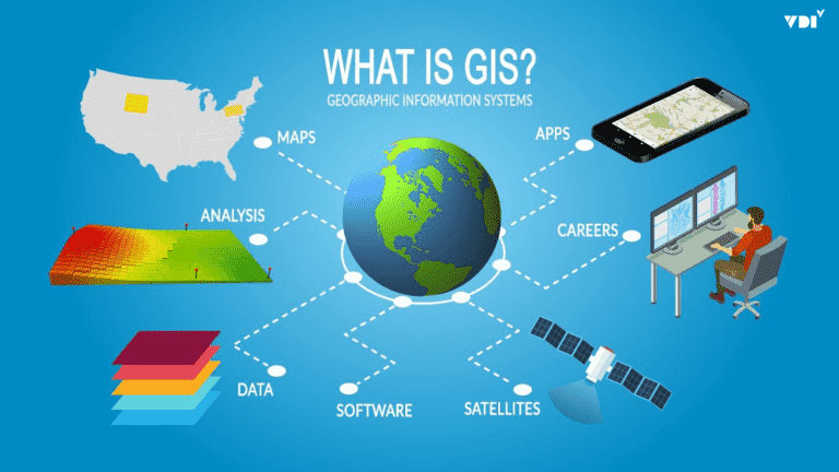
GIS is not just software for creating digital maps. It is a comprehensive system encompassing technology, processes, standards, and people, serving as the “central nervous system” of data within an organization.
2.1. Breaking down “data islands” with a spatial reference system
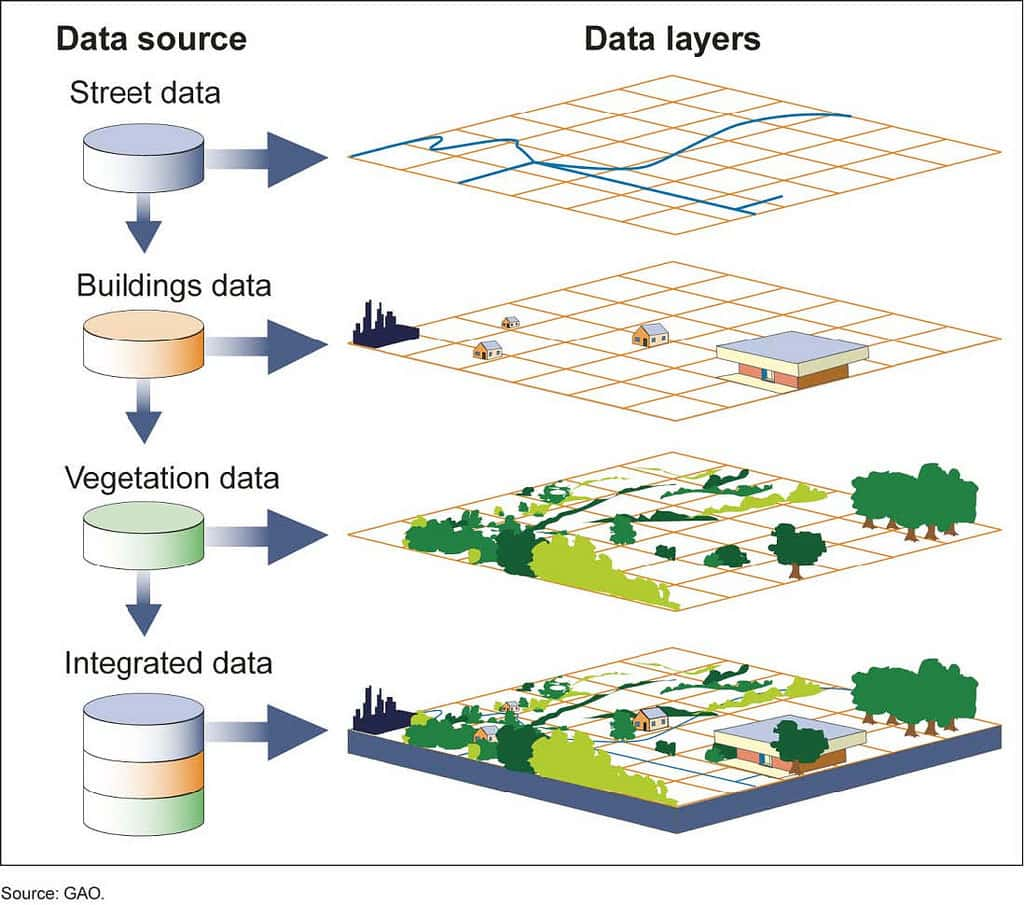
Every object of state management (land parcels, buildings, roads, electric poles, pumping stations, and so on) has one common and unique attribute: location. GIS uses this very attribute to link and integrate all disparate datasets. A land parcel on a GIS map carries not only cadastral information but can also be linked to construction planning information, construction permits, tax payment status, and the technical infrastructure running through it.
2.2. Building a shared spatial database (geodatabase)
GIS makes it possible to build a centralized, standardized spatial database that becomes the “single source of truth” for all units. When the Department of Natural Resources and Environment, the Department of Construction, and the Department of Transport all access and update a common data platform, conflicts and inconsistencies are eliminated thoroughly.
2.3. Turning data into intelligence for management
The greatest value of GIS lies in its spatial analysis capability, which turns raw data into knowledge and intelligence for decision-making:
- Overlay Analysis: Detects conflicts between types of planning.
- Network Analysis: Optimizes garbage collection routes and finds the shortest path for fire engines and ambulances.
- Buffer Analysis: Assesses the environmental impact of a factory and determines the range of residents affected when a water pipe bursts.
- Modeling & Prediction: Simulates the spread of pollution, forecasts areas at risk of landslides, and forecasts infrastructure demand in new urban areas.
3. An Effective GIS Implementation Roadmap for State Agencies
Implementing a comprehensive GIS is a strategic process. UNIGIS proposes a roadmap of 3 phases to ensure success, sustainability, and incremental added value.
Phase 1: Digitization and Standardization – Building a Solid Foundation
This is the most important phase, determining the success of the entire system.
- Objective: Create a foundational, accurate, and consistent spatial database (geodatabase) that complies with national standards (for example: the VN-2000 reference system, circulars on land and planning databases, and so on).
- Key actions:
- Review and collect all existing paper maps, CAD files, and records.
- Digitize, edit, and assign attributes to objects.
- Build the database structure and the rules and standards for data.
- Result: An accurate base digital map system, ready for the following phases.
Phase 2: Integration and Analysis – Unlocking the Value of Data
- Objective: Connect the GIS with other information systems and build specialized applications to support management work.
- Key actions:
- Develop connection gateways (APIs) to exchange data with document management software, e-one-stop-shop systems, and specialized management software.
- Build WebGIS and Mobile GIS applications for specific operations: permit management, construction inspection, infrastructure incident management, and so on.
- Train and build the capacity of staff to exploit and analyze data.
- Result: A marked improvement in work processing efficiency and multidimensional information for leaders.
Phase 3: Smart Operations and Openness – Toward an Enabling, Service-Oriented Government
- Objective: Use GIS as a tool to support strategic decision-making and to strengthen engagement with citizens and businesses.
- Key actions:
- Build Intelligent Operations Centers (IOC) for monitoring and management, with intuitive GIS dashboards as their “heart.”
- Apply AI and machine learning algorithms to analyze and forecast development trends.
- Build public Planning and Land Information Portals that allow citizens and businesses to look up information online, give feedback, and provide oversight.
- Result: A government that operates on data (data-driven), proactive and transparent, creating a favorable environment for development.
4. UNIGIS Vietnam’s Vision and Commitments
Our vision is to accompany the Vietnamese Government on its digital transformation journey, making GIS technology a core platform in state management and contributing to building a prosperous and sustainably developing nation.
As one of the pioneering and experienced companies in the GIS field in Vietnam, UNIGIS is committed to:
- Outstanding Technological Capability: Providing a comprehensive, modern GIS platform that can be flexibly customized to meet every specific operational need of state agencies.
- Extensive Implementation Experience: Having successfully implemented many complex GIS projects for Government agencies and large corporations, we deeply understand the processes and challenges in practice.
- Experts with Local Knowledge: Our experts are not only strong in technology but also well versed in the regulations, circulars, and standards of Vietnamese law in the fields of land, construction, and resources.
- Commitment to Safety, Security, and Compliance: Our platform puts data safety and security first, strictly complying with Government regulations on cybersecurity and national data sovereignty.
- Comprehensive Support and Technology Transfer: We are committed not only to building the system but also to training and transferring technology so that state agencies can fully master, operate, and develop the system sustainably.
Conclusion
The journey of building digital government is a long-term process that requires a strategic vision and a solid technology platform. Investing in a comprehensive Geographic Information System (GIS) is investing in the “infrastructure of infrastructure,” creating a seamless, transparent flow of data that underpins every management and operational decision.
UNIGIS is ready to be a strategic, trusted partner, bringing the most advanced GIS technology solutions together with a deep understanding of the management environment in Vietnam, to accompany you on the path to realizing the goals of National Digital Transformation.
To discuss the GIS implementation roadmap for your organization in more depth, please contact UNIGIS Vietnam — Hotline 024 6680 3123 · info@unigis.vn · unigis.vn