White Paper · September 26, 2025
Audience: Defense Leaders, Military Commanders at All Levels, Chief Technology Officers, and Stakeholders in the Defense Industry.

1. Executive Summary
In the era of information warfare, battlefield superiority is no longer determined by firepower alone but also by the ability to master information. The ability to collect, process, and act on accurate, timely intelligence is the core factor that makes the difference between success and failure. This white paper analyzes the revolutionary convergence of advanced remote sensing technologies and artificial intelligence (AI) as a key driver for achieving superior Situational Awareness (SA). We argue that integrating multimodal sensors, such as Synthetic Aperture Radar (SAR), LiDAR, hyperspectral imagery, and thermal imagery, with AI/Machine Learning (ML) algorithms is not merely a technology upgrade but a strategic paradigm shift. This combination makes it possible to transform a huge, fragmented volume of data into comprehensive, actionable intelligence in real time, shortening the decision-making cycle, strengthening force protection, and ensuring decisive operational superiority across every battlespace. This document presents a strategic roadmap for defense organizations to harness this synergy and secure a leading position in a volatile global security landscape.
2. Introduction: The Context of Modern Warfare and the Role of Information Superiority
The modern battlefield is increasingly complex, multidimensional, and high-tempo. Conflicts are no longer confined to the traditional domains of operation (land, sea, air) but have expanded into cyberspace and outer space. Adversaries are diverse, ranging from militarily powerful states to agile non-state groups, and they use asymmetric tactics, electronic warfare, and disinformation to erode conventional advantages.
In this context, the “fog of war” is growing ever thicker. Obtaining a clear, accurate, continuously updated Common Operational Picture (COP) has become a major challenge. As a result, information superiority, the ability to collect, process, analyze, and disseminate information faster and more effectively than the adversary, has become a decisive factor in victory. The force that can “see” more clearly, “understand” more deeply, and “act” faster seizes the strategic initiative, imposes its will on the adversary, and minimizes risk to its soldiers. Remote sensing and AI are the foundational technology pair for realizing this vision of absolute information superiority.
3. The Challenges: Limitations of Traditional Situational Awareness and Remote Sensing
Although current Intelligence, Surveillance, and Reconnaissance (ISR) systems have made great strides, they still face inherent limitations:
- Data overload: Modern ISR platforms (satellites, unmanned aerial vehicles, ground sensors) generate an enormous data deluge in diverse formats. Human manual analysis capacity cannot process it in a timely and effective manner, resulting in missed critical intelligence.
- One-sidedness of sensors: Each traditional sensor type (for example, optical imagery) provides only a limited view of the operating environment. They are easily affected by factors such as bad weather (clouds, rain), lighting conditions (darkness), and the adversary’s camouflage and concealment measures.
- Latency in the intelligence cycle: The traditional “tasking-to-dissemination” process is often slow. Data must be transmitted to a central hub, processed and analyzed by experts, and only then sent to operational units. This latency can render intelligence obsolete on a rapidly changing battlefield.
- Limits in recognizing sophisticated threats: Traditional systems struggle to detect small, fast-moving, or carefully camouflaged targets, or abnormal changes in the environment (for example, signs of an improvised explosive device, IED).
These challenges create “blind spots” in situational awareness, increasing risk to forces and limiting operational effectiveness.
4. Advanced Remote Sensing Technologies
To overcome these limitations, a new generation of remote sensing sensors provides richer and more resilient data collection in all conditions:
- Synthetic Aperture Radar (SAR): Using radio waves, SAR can “see” through clouds, rain, fog, and darkness. It is especially effective at detecting metal objects (tanks, warships), mapping detailed terrain, and detecting extremely small changes on the surface (for example, vehicle tracks), even when they have been concealed.
- LiDAR (Light Detection and Ranging): By emitting laser pulses and measuring the reflection time, LiDAR produces 3D point cloud maps with extremely high accuracy. This technology is invaluable for urban operations planning, identifying potential sniper positions, route analysis, and detecting concealed fortifications or obstacles.
- Hyperspectral Imaging (HSI): Instead of capturing images in just a few basic color bands (red, green, blue), HSI collects data from hundreds of narrow spectral bands. This lets it identify the unique “spectral signatures” of materials, helping distinguish real targets from decoys, detect disturbed vegetation (a sign of recent activity), and identify specific chemical materials from a distance.
- Thermal Imaging: Thermal sensors detect infrared energy emitted by objects, producing images based on temperature differences. They are extremely effective at night and can detect running vehicles, the heat signatures of soldiers, or areas with recent industrial or military activity.
- Multispectral Imaging: Similar to HSI but collecting fewer spectral bands, multispectral imagery still provides more information than standard optical imagery and is useful for environmental analysis, monitoring crop health (which may be affected by chemical agents), and terrain classification.
5. AI-Enhanced Situational Awareness
Advanced sensors alone only solve the problem of data collection. AI is the key to unlocking the value of that data. AI/ML transforms raw data into strategic intelligence through the following capabilities:
- Automatic Target Recognition (ATR): Deep learning algorithms, trained on millions of images and data samples, can automatically detect, classify, and recognize targets (for example, “T-90 tank,” “S-400 missile launcher”) from SAR, thermal, or optical data with speed and accuracy far beyond humans.
- Pattern Analysis and Forecasting: AI can analyze large datasets over time to identify adversary activity patterns (Patterns of Life), predict movement routes, and give early warning of abnormal activities that may signal an imminent attack.
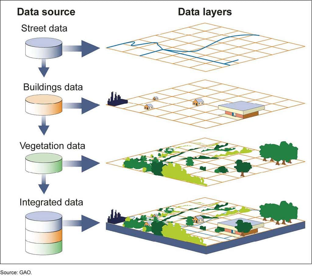
- Multi-Source Data Fusion (Sensor Fusion): This is the most important capability. AI can synthesize and cross-reference information from many different sensor types. For example, it can combine a thermal signal (from thermal imagery) with a metallic shape (from SAR) and a position within a known area (from a map) to confirm with high confidence that it is a hidden enemy tank, not a bus or a boulder.
- Semantic and Contextual Analysis: AI not only “sees” objects but also “understands” context. It can analyze terrain to identify potential ambush areas, assess textual intelligence reports, and link them with sensor data to produce a rich, in-depth intelligence picture.
6. Strategic Benefits
Adopting an integrated remote sensing and AI system brings profound strategic benefits:
- Shortening the OODA Loop (Observe - Orient - Decide - Act): By automating time-consuming analysis processes, AI delivers near-instant intelligence, allowing commanders to decide and act significantly faster than the adversary.
- Achieving Operational Superiority: Superior situational awareness lets forces carry out precise strikes and maneuver flexibly to exploit the adversary’s weaknesses and control the tempo of battle.
- Reducing Risk and Strengthening Force Protection: The ability to detect threats early, such as ambushes, IEDs, or enemy artillery, enables units to take preventive measures, saving many lives.
- Optimizing Resource Allocation: By providing a clear picture of the positions and intentions of both friendly and enemy forces, commanders can allocate valuable assets (such as fire support and ISR) most effectively.
7. Practical Scenarios and Applications
- Comprehensive Battlefield Surveillance: A network of satellites and unmanned aerial vehicles equipped with multimodal sensors, controlled by AI, can maintain continuous 24/7 surveillance over a large operational area, automatically flagging changes and targets of interest.
- Early Warning and Threat Deterrence: AI systems can analyze remote sensing data to detect signs of preparation for a missile attack or a border incursion, providing precious time to deploy countermeasures.
- Support for Autonomous Systems: Detailed 3D remote sensing data from LiDAR and target recognition from AI are critical inputs for autonomous ground and aerial vehicles, enabling them to navigate safely and carry out missions in complex environments without human intervention.
- Strategic Intelligence: By analyzing remote sensing data over the long term across an adversary’s military bases, industrial zones, or transport routes, AI can help build a deep picture of their capabilities, intentions, and strategic vulnerabilities.
8. Implementation Roadmap
To integrate these technologies successfully, defense organizations need a phased and systematic approach:
Phase 1: Building the Foundation (1-2 years)
- Infrastructure modernization: Invest in high-performance computing platforms, secure cloud storage, and broadband communications networks to handle the enormous data volume.
- Testing and evaluation (T&E): Procure and test various advanced remote sensing sensors in simulated operational scenarios.
- Workforce development: Begin training programs to build personnel skills in data science, AI, and multi-source intelligence analysis.
Phase 2: Integration and Automation (3-5 years)
- Develop an open architecture: Build an open system architecture that allows easy integration of sensors and AI algorithms from many different vendors.
- Deploy initial AI tools: Focus on high-impact applications such as ATR and automatic change detection.
- Establish AI ethics and governance processes: Set clear rules for the use of AI in military applications, ensuring human oversight (human-in-the-loop).
Phase 3: Full Operation and Optimization (5+ years)
- Deploy at scale: Integrate the system at all levels of command, from strategic headquarters to tactical units in the field.
- Achieve automated sensor-to-shooter fusion: Enable the system to automatically detect, verify, and propose courses of action against high-priority targets, with final approval by a human.
- Continuous improvement: Use data from real operations to continuously retrain and improve AI models.
9. Future Outlook: The Next Decade of AI and Remote Sensing
Over the next decade, we will see even more remarkable advances:
- AI at the Edge: AI algorithms will be built directly into sensors on unmanned aerial vehicles or satellites, enabling data to be processed and analyzed at the source. This will significantly reduce latency and bandwidth requirements.
- Explainable AI (XAI): Future AI systems will be able to explain why they reached a particular conclusion, strengthening human trust in machine-recommended decisions.
- Human-Machine Teaming: AI will become a true teammate, not only providing data but also proactively proposing courses of action, predicting outcomes, and managing complex autonomous systems.
- Quantum Computing: In the long term, quantum computing could revolutionize the ability to process extremely large ISR datasets and break current encryption methods, opening a new chapter in information warfare.
10. Conclusion: A Call to Action
The convergence of advanced remote sensing and artificial intelligence is not a distant future prospect; it is happening right now and will reshape the nature of warfare. Nations and defense organizations that delay embracing this transformative change risk falling behind strategically, facing growing risks on the battlefield.
Investing in these technologies is not just upgrading equipment but investing in superior decision-making ability, the most valuable strategic asset. We call on defense leaders to act decisively: prioritize investment in data infrastructure, advance AI research and development, and build a workforce ready for the era of algorithmic warfare. The road ahead is challenging, but the reward, a military force that is more agile, smarter, and more effective, able to dominate the battlefield and protect national interests, is well worth it. Superiority in the future belongs to those who can master information.