In remote sensing and geospatial analysis, ENVI and SARscape are two leading names, offering deep scientific capabilities for extracting information from imagery. Since being acquired by NV5 Geospatial, these solutions have continued to receive investment and development, confirming their position as an indispensable toolset for scientists, researchers, and analysts.
ENVI: The “Operating System” for Remote Sensing Data
Think of ENVI (Environment for Visualizing Images) as a central platform, or an “operating system,” for every kind of imagery data. To use any function, you need the ENVI Base license. The other modules are “specialized applications” installed on top to extend the capabilities of this platform.
1. ENVI (Base License)
This license provides the full set of foundational tools for image processing and analysis.
- Technical Capabilities: Reading and writing hundreds of data formats, geometric correction, basic radiometric correction, band combination changes, calculation of common indices (such as NDVI), supervised and unsupervised image classification, basic raster and vector processing tools, and the visual programming interface ENVI Modeler.
- Practical Application Examples:
- Agricultural Management: Use free Sentinel-2 satellite imagery to calculate the NDVI index, quickly producing crop health maps and identifying areas that need fertilizer or irrigation.
- Water Resources Monitoring: Use Landsat imagery to calculate the NDWI (Normalized Difference Water Index) to delineate lakes and wetlands and track changes in their extent over many years.
- Basic Land Cover Mapping: Run unsupervised classification on aerial imagery to produce a preliminary classification map of urban areas, vegetation, and water bodies.
- Data Preparation for GIS: Orthorectify and mosaic raw drone images into a single, highly accurate basemap for use in ArcGIS Pro.
- Rapid Change Detection: Compare two images taken at different times using image differencing to quickly detect areas of major change, for example a recently deforested area.
2. ENVI Extension Modules
a. ENVI Atmospheric Correction Module
- Dependency: Requires the ENVI Base license.
- Technical Capabilities: Provides state-of-the-art scientific algorithms such as FLAASH and QUAC to remove the effects of water vapor, aerosols, and haze in the atmosphere. This converts pixel values into true surface reflectance, a critically important step for quantitative analysis and scientific comparison.
- Practical Application Examples:
- Multitemporal Analysis: Accurately compare changes in vegetation between an image taken in the dry season (few clouds) and one taken in the rainy season (more water vapor in the air).
- Water Quality Studies: After atmospheric correction, scientists can analyze the spectra of the water surface to estimate chlorophyll or suspended solids concentrations.
- Accurate Forest Classification: Haze removal helps classification algorithms better distinguish between coniferous and broadleaf forests that have nearly identical spectral characteristics.
- Geology and Mining: Obtaining “clean” spectral values is required to compare against mineral spectral libraries and identify potential areas.
- Calibration and Validation (Cal/Val): Used to calibrate satellite data against field spectral measurements, ensuring the consistency and scientific rigor of the data.
b. ENVI LiDAR Module
- Dependency: Requires the ENVI Base license.
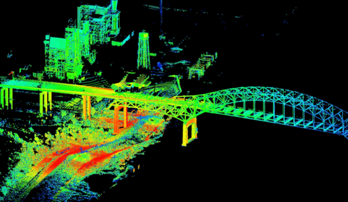
- Technical Capabilities: Provides a complete toolset for working with point cloud data from LiDAR technology. It enables 3D visualization, filtering, classification of points (ground, buildings, vegetation), and extraction of products such as the Digital Elevation Model (DEM), the Digital Surface Model (DSM), and 3D features (buildings, trees).
- Practical Application Examples:
- Forest Management: Classify LiDAR points into ground and canopy layers, then accurately calculate tree height, canopy cover density, and estimate biomass for individual trees.
- 3D Urban Planning: Automatically extract 3D building blocks from LiDAR data to create a digital model of the city, supporting visibility analysis and construction planning.
- Flood Zone Mapping: Create an ultra-accurate DEM from LiDAR points classified as “ground,” an indispensable foundation for detailed hydrological and flood simulations.
- Power Line Corridor Management: Automatically identify trees growing too close to power lines by analyzing the distance between vegetation LiDAR points and power line points.
- Archaeology: Detect ancient structures buried beneath dense forest canopy by removing all LiDAR points belonging to vegetation and keeping only the ground points.
Note: According to the article “LiDAR Processing in ENVI,” LiDAR processing capabilities are now integrated into the ENVI Base license.
c. ENVI Deep Learning Module
- Dependency: Requires the ENVI Base license.
- Technical Capabilities: Integrates Artificial Intelligence (AI) frameworks such as TensorFlow and Keras into ENVI. Provides a visual interface so users without programming expertise can easily create training data, train deep learning models, and apply them to automate complex object recognition and extraction tasks.
- Practical Application Examples:
- Asset Inventory: Train a model to automatically detect and count all rooftop solar panels in a city from aerial imagery.
- Disaster Assessment: After a storm, apply a trained AI model to automatically delineate and classify the damage level of each building (minor, moderate, completely collapsed).
- Traffic Monitoring: Automatically count and classify vehicle types (cars, trucks) in large parking lots or on highways from very high resolution satellite imagery.
- Precision Agriculture: Detect and delineate crops infected with a specific disease based on color and texture characteristics that are difficult to distinguish with the naked eye.
- Security and Defense: Automatically identify and mark the locations of military equipment (aircraft, tanks) camouflaged in a variety of terrain settings.
SARscape: The Radar Data Analysis Specialist
SARscape is an extremely powerful module that runs inside the ENVI environment, dedicated to Radar (SAR) data. To use SARscape, you must have the ENVI Base license. SARscape itself also has a tiered license structure.
1. SARscape Basic & Core Modules
These are the foundational SARscape licenses, providing the basic SAR processing tools.
- Technical Capabilities: Reading SAR data from most sensors, multilooking, speckle filtering, geometric correction, and signal intensity analysis.
- Practical Application Examples:
- Flood Mapping: Accurately delineate flooded areas regardless of cloud cover, based on the principle that a flat water surface reflects the radar signal away and appears dark in the image.
- Deforestation Detection: Detect recently cleared forest areas, because the change from a rough canopy to bare ground significantly alters the intensity of the returned radar signal.
- Marine Oil Spill Monitoring: Oil makes the sea surface smoother, creating dark areas in SAR imagery, helping environmental agencies detect and track oil slicks.
- Ship Detection: Metal ships reflect the radar signal very strongly and appear as bright points against the dark sea, used in maritime security and to combat illegal fishing.
- Agricultural Classification: Distinguish different crop types (for example, paddy rice and field crops) based on differences in plant geometric structure, which affect how the radar signal is scattered.
2. SARscape Extension Modules
a. SARscape Interferometry (InSAR/DInSAR) Module
- Dependency: Requires the ENVI Base license and SARscape Core.
- Technical Capabilities: Provides tools for radar interferometry. It enables creating a Digital Elevation Model (DEM) and measuring surface displacement that occurs between two image acquisitions, commonly used to analyze sudden deformation events.
- Practical Application Examples:
- Earthquake Analysis: Produce detailed maps of ground deformation (uplift and subsidence) after a major earthquake.
- Volcano Monitoring: Detect the swelling of a volcano’s flanks, an early warning sign of an impending eruption.
- Landslide Analysis: Measure the displacement of a large landslide to assess its scale and impact.
- Topographic Mapping: Create a high-accuracy DEM for areas frequently covered by clouds, where optical methods are ineffective.
- Glacier Monitoring: Measure the flow speed of glaciers.
b. SARscape Interferometric Stacking (PS/SBAS) Module
- Dependency: Requires the ENVI Base license, SARscape Core, and SARscape Interferometry.
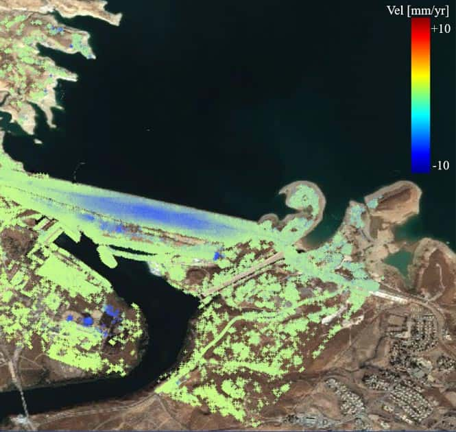
- Technical Capabilities: This is the most advanced module, using SAR time-series processing algorithms (such as PS and SBAS) to measure slow, prolonged, and very small displacements (millimeters per year) with extremely high accuracy.
- Practical Application Examples:
- Urban Subsidence Monitoring: Produce annual subsidence rate maps for large urban areas caused by groundwater extraction, helping planners identify high-risk areas.
- Hydropower Dam Health Monitoring: Continuously monitor deformation of the dam body and surrounding slopes to detect early signs of instability.
- Transportation Infrastructure Monitoring: Monitor the stability of large bridges, highways, and airport runways, detecting settlement or displacement that could be dangerous.
- Mining Management: Monitor surface subsidence caused by underground mining activity, ensuring the safety of nearby residential areas.
- Tunnel and Metro Monitoring: Monitor ground deformation above underground structures such as tunnels or metro lines during and after construction.
Operating Diagram and License Dependencies
The relationships between the software components can be visualized as follows:
- ENVI (Base License) — the foundation
- Extension modules:
- ENVI Atmospheric Correction
- ENVI LiDAR
- ENVI Deep Learning
- SARscape (requires ENVI Base to run)
- SARscape Basic/Core Modules
- SARscape Interferometry (InSAR/DInSAR)
- SARscape Interferometric Stacking (PS/SBAS)
- SARscape Interferometry (InSAR/DInSAR)
- SARscape Basic/Core Modules
- Extension modules:
In other words, you cannot buy the Stacking module without the Interferometry module, you cannot buy the Interferometry module without SARscape Core, and you cannot run any SARscape module without the ENVI Base license.