In today’s connected world, data is no longer static. Billions of devices, from smartphones, vehicles and environmental sensors to industrial assets, are continuously generating streams of real-time data. Capturing, analyzing and reacting immediately to this information is a key element of competitive advantage. ArcGIS GeoEvent Server, a specialized server role of ArcGIS Enterprise, is Esri’s solution that helps you harness the power of real-time data, turning events as they happen into immediately actionable insight.
What Is ArcGIS GeoEvent Server?
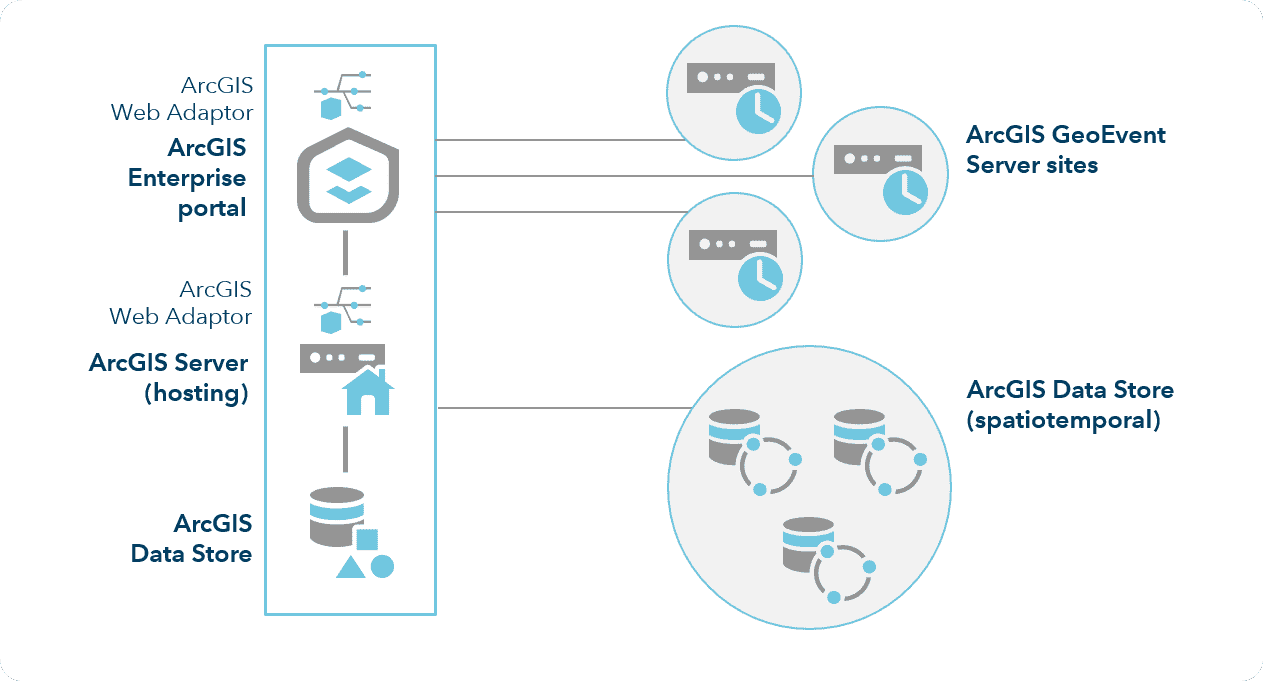
ArcGIS GeoEvent Server is a licensing role of ArcGIS Enterprise that lets you connect to almost any type of streaming data source, and process and analyze these data streams continuously as they are generated. It works as a Complex Event Processing system, allowing you to filter, enrich, and detect patterns or important conditions in data in motion without having to store it in a database first.
Fundamentally, GeoEvent Server helps you answer the question “What is happening right now?” by providing tools to define automated processing workflows and alerts, helping your organization shift from analyzing historical data to monitoring and responding to events in real time.
Core Capabilities of ArcGIS GeoEvent Server
GeoEvent Server provides a flexible set of tools for building real-time GIS applications.
1. Multi-Source Connectivity (Ingestion)
It can ingest data from countless different sources through configurable “Inputs”:
- GPS data: From vehicle tracking devices (AVL), mobile phones or wearable devices.
- IoT sensors: Data from temperature, humidity, pressure, noise or water level sensors.
- Social media: Public posts from Twitter and Instagram that contain location information.
- Data providers: Weather, traffic, or aircraft and ship data from third-party services.
- Other enterprise systems: Data from SCADA systems, security cameras, or other business applications.
2. Continuous Processing and Analytics
The heart of GeoEvent Server is the ability to build visual processing models (called GeoEvent Services) by combining Filters and Processors:
- Spatial filtering: Processing only events that occur inside a geographic area of interest (for example: a district, an industrial zone, or a safety corridor).
- Attribute filtering: Filtering events based on their values (for example: only vehicles exceeding 80 km/h, or sensors with temperatures above 50°C).
- Data enrichment: Automatically adding useful location information to incoming data. For example, when a vehicle sends its coordinates, the system can automatically add information about the street, ward and district it is passing through.
- Pattern detection: Recognizing complex patterns such as a vehicle entering a restricted area, a sensor continuously reporting abnormal values, or two objects moving too close to each other.
3. Dissemination and Alerting
After processing, GeoEvent Server can push information out through “Outputs” to trigger immediate actions:
- Map updates: Displaying the latest location and status of objects on a web map or an operations dashboard.
- Sending alerts: Automatically sending emails, SMS messages, or push notifications to responsible people when an important condition is met.
- Data storage: Storing important events in a data store (for example: the Spatiotemporal Big Data Store) for later historical analysis.
- Integration with other systems: Sending commands to other systems, for example activating a security camera, raising a barrier, or creating a work order in a work management system.
Notable Use Cases
The capabilities of GeoEvent Server open up countless applications across many industries.
1. Transportation and Logistics
Transportation companies and traffic management agencies use GeoEvent Server to optimize operations.
- Smart fleet management: Tracking the locations of hundreds of trucks in real time. Automatically alerting when a vehicle leaves its planned route, stops for too long, or exceeds the permitted speed.
- Urban traffic monitoring: Integrating data from traffic sensors, cameras and GPS data from buses to create a live traffic condition map, helping coordinate traffic signals and inform residents about congestion points.
- Estimated time of arrival (ETA): Continuously updating the expected arrival time of buses or shipments based on actual location and traffic conditions.
2. Utilities and Energy
Electric, water and telecommunications companies monitor their networks to ensure continuous operation.
- Smart Grid: Monitoring data from sensors on the power grid. Automatically identifying and isolating an outage as soon as it occurs, helping dispatch repair crews to the exact location quickly.
- Pipeline leak detection: Analyzing pressure and flow data from sensors along water or gas pipelines. Alerting immediately when an abnormal pressure drop that may indicate a leak is detected.
- Field workforce management: Tracking the locations of engineers and workers. When an incident occurs, the system can automatically find and dispatch the nearest staff member with the appropriate skills to the scene.
3. Public Safety and Emergency Management
Police, fire and ambulance agencies use GeoEvent Server to improve response times.
- Smart dispatch system: Displaying the locations of all police, fire and ambulance vehicles on a single map. When an emergency call comes in, the system automatically suggests the nearest and most suitable unit to dispatch.
- Large event monitoring: Setting up “geofences” around event venues (festivals, marathons). Alerting the command center when a crowd gathers beyond the permitted density or when a vehicle enters a restricted area.
- Extreme weather warnings: Integrating data from weather stations. Automatically sending warnings to residents in a specific area when dangerous weather conditions (flash floods, storms) are detected approaching.
4. Environmental and Agricultural Management
Scientists and environmental agencies track key indicators in nature.
- Air and water quality monitoring: Continuously collecting data from monitoring stations. Producing interpolated maps of pollution levels in real time and alerting when indicators exceed safe thresholds.
- Wildlife tracking: Analyzing data from GPS collars on animals to study migration behavior, identify potential conflicts with humans, and alert when animals enter dangerous areas.
Conclusion
ArcGIS GeoEvent Server is the bridge between the GIS world and the world of the Internet of Things (IoT). It gives organizations the ability to sense, analyze and react to events as they happen. By automating monitoring and alerting, GeoEvent Server helps reduce risk, optimize operational efficiency and deliver better services to customers and the community.